Tham Luang Nang Non
| Tham Luang Nang Non | |
|---|---|
| Tham Luang Tham Nam Cham Tham Yai | |
Cave entrance in 2018 | |
| Location | Tham Luang–Khun Nam Nang Non Forest Park, Mae Sai, Chiang Rai Province, Thailand |
| Coordinates | 20°22′54″N 99°52′06″E / 20.38167°N 99.86833°E |
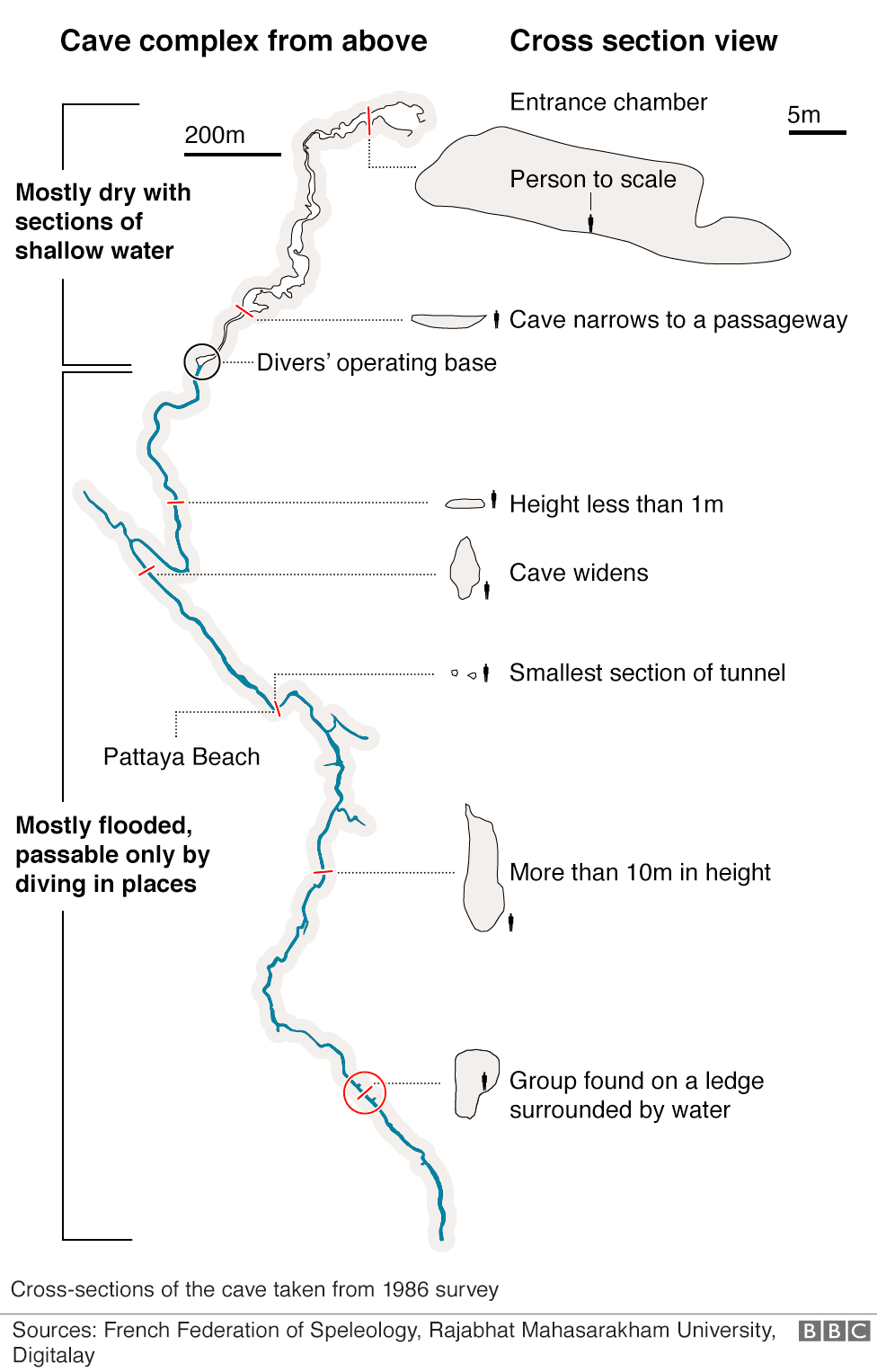
| Depth | 85 metres (279 ft) |
| Length | 10.3 kilometres (6.4 mi) |
| Elevation | 446 metres (1,463 ft) |
| Geology | Karst cave |
| Hazards | Monsoon flooding |
| Access | Tours available (November – April) |
| Lighting | None (before the rescue operation) |
Tham Luang Nang Non (Thai: ถ้ำหลวงนางนอน, lit. 'Great Cave of the Sleeping Lady', RTGS: Tham Luang Nang Non, pronounced [tʰâm lǔaŋ nāːŋ nɔ̄ːn]), also known as Tham Luang or Tham Yai, is a karstic cave system in the Tham Luang–Khun Nam Nang Non Forest Park, near the village of Ban Chong in Pong Pha subdistrict, in northern Thailand. It lies beneath Doi Nang Non, a mountain range on the border with Myanmar.
Previously known only to locals, Tham Luang Cave came to global attention when twelve members of a junior association football team and their assistant coach were found alive deep inside the cave on 2 July 2018 after they were trapped by monsoonal flooding on 23 June. A rescue mission brought everyone out safely by 10 July. Two Thai rescue divers died during the mission.
Tham Luang is the fourth largest cave in Thailand, stretching through a series of winding halls, low ceilings, rock collapses, and deep recesses with stalactites, stalagmites, and reflective stone surfaces. It is open to guided tours from November to April, though many parts remain inaccessible.
| External images | |
|---|---|
| Map, from above, of the Tham Luang cave system, provided by BBC News | |
| Map, side view, of the Tham Luang cave system, provided by Deutsche Welle |